2000 – Colorado River & BeyondView from a Traveler’s Perspective |
||||||
|
(It’s a book)
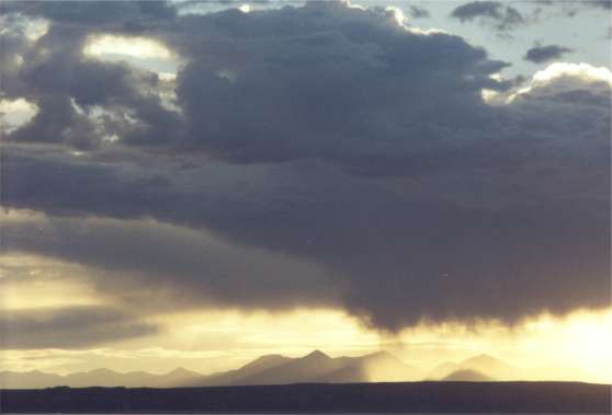
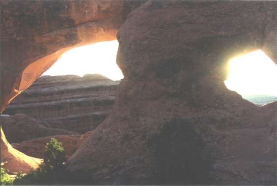
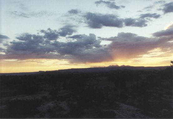
. Well the day has arrived. Today it’s strip the bed. Wash the sheets and comforter. Reapply them for a fresh return home environment. Car’s 98% packed. A quick power wash should alert me of any potential leak from the new windshield installed 48 hours ago. Close timing, the instruction was to wait 48 hours to let the adhesive fully set up. Checking off each item on the "leaving" list there are only two items remaining before heading to Utah. Through Vince a salesman I’ve been casually talking with at HiFi Buys for over eight months, submitted a cover letter and resume for a sales position at a new store opening less than 2 miles from the house. It appears to be the best location of any of their Atlanta stores. Vince advised it would be opening while I’m away. Having spotted the store under preparation 30 hours ago, my rush to complete these papers before leaving had some merit. Why HiFi Buys? Stereo's the hobby. Why not see if there's some fun while working. There’s still a medical appointment at 2PM, then Atlanta becomes history. Pre-trip jitters as a companion for several days are not sorted out yet. Has everything been thought of and addressed? Is the house safe? What challenges will the river have for us? Will the drive west be taxing? All of these are conditions cured by a relaxed mind. It’s easy to say, harder to accomplish. Morning was non-stop. Early afternoon was scheduled to perfection. If I can just get out of Atlanta before rush hour, the weeks before our river put-on will slide into place. Pre-river jitters should quell the first day on water. The unknown factor is, what river changes the Park Service test of continuous 8,000 cubic feet per second will bring. Concerns for increased river volume may be true for rivers in general but the Colorado has a two edged sword. It may be more difficult when high but it’s also reported to be dicey when low. Low it gets technical as well as pushy. The test volume may be high for eastern topography but it's low for western terrain. It's very low for the Colorado. Left Atlanta at 3:00PM from route 400 and I-285. Stopped long enough to top off gas and roared out of town up I-75 toward Chattanooga, TN. The plan, see how far the night will go without strain. First night’s stop option might be just the other side of Chattanooga beside a lake. It’s a short hall from Atlanta but who knows what traffic will bring. Thursday 6/22/00 5:30AM With a Porsche wake up alarm this morning from a fellow rest area traveler parked next space over, it’s wash up, shave and off from Benton, IL. Got further than expected last night. After a gas up in St Louis, MO and a brief detour (missed I-70 interchange having failed to note the interstate change on the AAA map) stopped 40 mile out of town for a nap. The unwanted wake-up call had been too early. 5:30AM eastern, 4:30AM central was pitch black out but allowed passage through St Louis minus traffic. By 8:00AM eastern was off again. Pre-trip calculations had highlighted some timing. If, without strain, the area of Moab, UT could be reached Saturday morning instead of mid afternoon, a campsite might be secured at Arches National Park. First come, first served is a rule at many national parks. The goal now was to reach Denver, CO plus some miles to be within morning’s reach of Moab. Pounded by hard headwinds all afternoon, the heavily loaded Honda struggled under the resistance of a canoe and Tule car top carrier. Pushing, it labored at 80 and often 75mph was all it could do. The psyche of a few western towns, passed through on this trip, seems to shout with the excitement of being physical or out there. Having stopped for two hour in Denver on the way out and having succeeded with the timing by not arriving too late, a last minute opportunity workout and shower at Bally’s gym left the impression they were much better equipped for any kind of workout than their Atlanta counterparts. It felt like kayaker’s, climber’s, canoeist’s, rafter’s, mountain biker’s, hiker’s preparation and augmentation heaven. This western ambiance if not an active person’s environment is perhaps alternatively keeping the faith with crafts, art or local culture. Perhaps it’s merely a sense of focused involvement in the basics. With fewer people than back east, it’s easier to sense this participation. Friday 6/23/00 6:15AM rest area I-70 Blair Ranch rest area nestled between the Colorado River and I-70 140 miles west of Denver is a quiet small landscaped rest area that feels like welcome. It must be 50 – 55 degrees. There’s a boat access as in canoe / kayak and a paved bike path leading up and down the river. Blair Family Ranch is across the river over a ½ to 1 million dollar common road bridge. The Colorado is upper Delaware River wide already. Even with the sound of trucks working their way up the mountain, I-70’s Glenwood Canyon should be celebrated. The route west out of Denver was severe, forcing the Honda down into third gear on occasion in order to maintain a speed above 50mph. I-70 goes vertical as it twists and wriggles into the Rockies. It’s a struggle recognized by anyone un-jaded by the driver’s seat of a 3 ton gas guzzling, emissions producing, luxuriously outfitted, monster engine SUV which cruise these "hills" as if up were down. Glenwood Canyon, they say, is the most celebrated 12.5-mile section of interstate in the nation. It is both a marvel of engineering as it mimics the Colorado’s flow and an example of how we can co-exist with nature. In a tightly cut gorge the Colorado, a single-track railroad and a 4 lane interstate co-mingle. Except for the noise of traffic, even the highway is little to abhor. The rest area could be any mini National Park Service offering. Being ahead of my most optimistic schedule offers an early morning respite to see four small rest areas, a surprise for anyone previously unaware. If we treated the rest of our nation this well there would be no environmental issues. Instead there would be pride and celebration. I’ve never seen a highway to which returning for biking or canoeing is thought provoking. It’s been all down hill after I-70 reached 6,600 feet elevation. Now it has become a valley with impressive walls even though industry is obvious all around. The rest area near Rifle, containing the information center, is unfriendly. It shouts, stop here only if you plan on finding out where to spend money. Do not stop long. Exit 47 I-70 Colorado has camping at the Colorado River State Island Park and gas is available at the Utah exit of I-70 toward Moab. The camping and gas information were missing from the AAA map. Saturday 6/24/00 7:03AM local time Where to begin? It’s Saturday morning and I’m leaning back against a Platypus hydration pack. Both of us are firmly outstretched on a 25-degree rock-slope facing Private Arch in Arches National Park, Utah. Located almost 2/3rds of the distance clockwise along the Devils Garden loop-trail (including Primitive Trail) if you have walked to all trail associated arches and a spire called Dark Angel. Devils Garden is considered to be a 4 to 5 hour hike approximately 7 miles long. Today was an early rise day at 3:30AM mountain time, too early if honest. Springtime for this dessert, the two near by evergreen trees, both the size of large shrubs at 4 and 5 feet tall, show signs of seeds. One has a sky blue berry ¼ inch in diameter. The other is growing what look like small Ponderosa pinecones almost at the tips of branches. Where there is earth among exposed sandstone life hangs on. Needless to say I’ve been alone all morning. It rained here late afternoon and evening yesterday. Footprints in these kern marked trails were all faded out from pounding raindrops. Mine are the first visible today. The effort destroyed an occasional cross-trail spider’s work of art. Primitive trail does require some minor rock scrambling but is not difficult. One-quarter way between Private Arch and rejoining with Devils Garden trail presented boot prints of one person who had apparently turned back. Three-quarters of the way back along this section, footprints from a party of two had also turned back. Almost at the confluence of this loop trail, a man and woman, first site of people today, were likely to join the others. She had a daypack. Hope she was carrying the water. He had nothing. Just at the confluence a young couple were better prepared with hydration packs. Back at the trailhead parking lot at 9AM there were many people beginning all or part of this 7-mile loop. By 11:15AM, having completed an added short hike 2.5 miles round trip to Broken Arch and Sandstone Arch it would have been better to have figured out a mile could have been saved by realizing that Sandstone Arch can be reached via a two city block length walk from a parked car. This story has gotten far ahead of itself. Having arrived yesterday at the entrance to Arches NP, the first discovery is you must take water with you. Available from a spigot beside the visitors’ center and 40 minutes away at Devils Garden trailhead, the other extreme end of the park road, it’s a must on the hot dessert plateau above you where natural stone arches have formed. Five miles from Moab the park’s road climbs dramatically up the side of the plateau. Atop in open spaces and dry dessert air your tour begins at roadside viewpoints. Mine began as a get acquainted day and scheduling for the ranger tour of Fiery Furnace at 10AM in two days, their earliest opening. At $6 it’s held once a day. Having burned up a chunk of the day and getting information at the center the plan was to drive to the other end of the park, take the only non-4 wheel drive dirt road in the park 9 miles in for the 3.4 mile round trip hike to Tower Arch, an isolated trip unlikely to happen another day. Like the ranger said, a higher speed gets you skipping a few of the washboard undulations and was the first serious car abuse of the trip. Mid-day here is very hot. The elevation makes the sun intense. The hike was a test of body condition and hiking in Chaco sandals. Both passed. This is a very isolated hike with only one couple sited from parking to exiting the dirt road. With no park campsites available, (first come first served, they line up at 7:30AM), the next best location was BLM (Bureau of Land Management) primitive campsites 5 miles from the park on route 128 along the Colorado River. Opted for the cheaper site (has a fence around but no overhead cover above the outhouse toilet) $5 per day ($2.50, 1/2 price with your Golden Access Card number). The option turned out to be better than the park. You have the river for an unofficial bath, some mid-day shade and cooler temperature than atop the plateau. Arches campground has water but not for bathing. The BLM campground has no drinking water but there is spring water on route 128 just off the route 191 intersections, Moab to the left, Arches NP to the right. The BLM sites must also be secured early, perhaps before noon. The process is simple. Fill out envelope and stub provided from a box. Put money in the envelope and seal. Stuff the envelope minus stub into a money slot in a locked metal post. Attach the stub to a post designating your site. Back at the campsite for a bath in the Colorado around noon after this morning’s hikes at Devils Garden and Sand Dune Arch. This naptime out of the mid-day sun is too buggy. Will look elsewhere once clean. To digress a little, the trusty digital BOSS organizer went off at 3:30AM. No wonder I felt short sheeted. The BOSS organizer, used as an alarm clock can be set to display time zones. It sets alarms based on your home time (eastern) regardless of the time zone you’re looking at. The error was used to drive to Arches visitors’ center for morning spruce up and birdbath laundry. The center is closed at this hour but the rest rooms aren’t. The early rise was planned for photo ops of sunrise at a Devils Garden trail arch, a 40-minute drive within the park plus hiking time. It worked out well. With a 5:50AM trail start it was still about 20 minutes late for beginning sunrise at an arch. Speeding the length of the park’s paved roadway and eating previously prepared P&J on Jewish rye in motion on the trail permitted as much sunrise among arches as could be gained by scurrying from arch to arch. Then a large cloud took over the light. Great hiking environment, nix rising sun picture taking. At 2:15PM the attempted nap is over. Even in the shade it’s hot. Besides an occasional fly buzzing during lights out, there was the camper having a go at locating me vocally. Seems he had removed my permit stub thinking me a one nighter and replaced it with his own. He was attempting to locate the usurper (me). Unaware of any gained sleep even with the few wisps of suggested cool breeze, clean at least, all effort will be made to remain clean until the 1.5 mile hike out to Delicate Arch starting at 6:30PM to catch sunset "in just the right place". Tomorrow it’s the 3-hour Fiery Furnace ranger-lead hike, the only way allowed into this area other than special permit. Be on time, no refunds, bring water and wear hiking boots for the rock scrambling are the instructions. Interesting, my old Teva Guide sandals were not for hiking. Both they and my feet wound up taped to halt foot destruction. With my new Chaco Z1 sandals worn with a pair of socks, the shoe is on the other foot or is it if the shoe fits? Hiking thus far today has included 9.5 miles in control and comfort. Today’s habit of carrying the boots in case should be good for tomorrow. For the Grand Canyon, one pair of good wool hiking socks should do but the boots will be there in case. At 4:10PM finding a place to make late lunch or early dinner rules all thought. At 8:15PM you may wonder why my body is comfortably laid back in a folding chair, complete with armrests, headrests and foot support. Try, it’s overcast for the second evening and a 3-mile round trip hike for a not happening sunset does not appeal to a 10-mile-trail-day-old body. This route 128 roadside pullover beside the Colorado is less sweaty than a hike and less bug filled than camp ½ mile away. Besides, sitting next to the car’s passenger window, viewing sandstone cliffs can be augmented by an Elton John CD. When it cools more or darkens, the campsite should be bug free. It was last night. I don’t know why they were there but coming over a rise last night showed why some cliffs appeared lit in spite of the darkness. Perhaps it was a pickup truck with a specialized generator and four 18-inch monster halogen lamps mounted on a roof rack creeping forward opposite my direction. First I flashed high beams, then a long blast, then reality. There was no way to see the road. The Honda slowed to a literal crawl. With sun visor lowered to block the light we inched forward until passed these fools. Ah yes, light bulb, keeping this campsite one more day would provide the option of another Colorado bath following tomorrows hike. Staying one more night might open up campsites at Canyonlands NP the following morning. Sunday 6/25/00 Sunday morning and life revolves around the Fiery Furnace ranger lead hike. Awake at 6:30AM, filled out a campsite permit for tonight. Drove to route 128 and 191 junctions to a picnic area (tables supplied by Moab Lions Club) to a covered pit toilet. A couple of city blocks distance back up 128 is the spring, a pipe concreted in and most effective. The outflow passes under 128 to the Colorado behind bushes across the road. It’s clean water for a morning shave beside the river. Sand Dune Arch is one of the easiest to get to and small enough to be a very quiet place to wait out time before a hike. Its other advantage is it’s between two large vertical slabs of sandstone that essentially block out direct sunlight, creating a cool corridor with a gentle breeze. Only about 300 yards from the road, you’re in an oasis with interesting formations and some naturally well-placed greenery. What more could you ask for when being in the sun is already hot. Almost brought in the folding chair. Didn’t want to stand out that much if anyone happened by. Cool, comfortable earth tone sand is a bottoms delight. Five PM brings a somewhat tired but clean and refreshed traveler back to Sand Dune Arch. Fiery Furnace, a hike in among fins of vertical rock is well worth the cost and hiking effort. A must do if moderate hiking and rock scrambling isn’t a trial for you. It ends just in time. Hiking from 1PM to 6PM plus is out. The temperature in the sun feels above the boiling point and can be arduous even in the shade. Best option; take a snooze in a shady spot, preferably reclined in a chair. After two previous days of clouds, today appears a good shot at Delicate Arch. In the shade at Sand Stone Arch, water bottle at hand and reclined in a chair is a good way to wait. By the way, if in you’re travels you are on the Fiery Furnace hike and a ranger says something about Kissing Rock Arch, yours truly gave it it’s name submitted on the basis you need to kiss the rock to which the arch is attached in order to see the arch. Just had a passer-by, tall slender man accompanied by young daughter, appreciate my sense of comfort. He asked if I had been back in the Fiery Furnace, likely a response to the similar fins surrounding us. Following the obvious response, the question, "Have you been on the tour?" brought "No". "Oh, you went on a permit." "No, you just go back in there. It’s extensive." Seeing nothing to be gained by embarrassing this man in front of his daughter, no comment was made. There are valid environmental reasons for requiring a permit. An observation: considering the size of the US population in comparison to the neighborhood of Europe, the slanted proportion toward foreign languages that pass by is disheartening. We are either working too hard or have the wrong family values. Earth-tone grains of sand passing before my pen was first an indication that the warm breezes had changed and second that something was afoot. A look down the parallel sandstone fins approximately 30 feet apart brought the news. No scattered clouds sunset tonight. They have become overcast to the west though still scattered to the east. Plan B and current pen location is the Windows section of the park. This is the place. If you have time for nothing else, spend what you have here. There are more arches here in one place and you can walk to or climb within them from easy short trails. Within the largest and most complex there is a place to put your bottom, comfortably supported from below with a 45 degree angled backrest about 5 stories up inside the arch on the far right wall viewed from the approach. At best this natural rock formation accommodates two and is likely the best viewing spot. You can see all of the structure to advantage in a relaxed body position. Arriving very late helps remove the cacophony that easily echoes about from classic tourists short on time to reflect upon their surroundings or enjoy the chipmunks animated without their presence. Other than their tourist noise they are a fun addition viewed scrambling up and down rock. Dotting the landscape they add scale and humanity facing minor challenges both relational and physical. There’d be an ugly blood trail if some of these people (coddled to the point of oblivion) who climb 6 to 8 stories with inadequately prepared skills or a planned route down, slipped. The possible climbs up are fortunately forgiving. Still, it’s scary to watch. Finally late enough, it’s solitude and three portals through which to view the sky or discover the landscape. 3 Arches National Park General Impressions
It is difficult to internalize the subtle beauty of either the majestic or small offerings of this park on the fly. Two full days, with effort, will get you to all or most designations on the park’s map. This is enough to allow you to pick areas to come back to and hang out in for a more metaphysical experience in future. In all there are limited major sites of narrow focus interest. Obvious hiking trails are very few with valid reason. Your restricted access to a seemingly vast expanse can seem questionable. The Park Service is not making clear to the general entrant the dire sensitivity of the ecological basis for the area. Walk on it, the thin-layer bottom rung of the food chain and it turns from life giving soil to sand dunes. Studies are beginning to suggest that the nitrogen fixing life form that keeps the surface sand bound together allowing plants to take hold in a non-shifting environment developed in a different environment. Therefore when damaged it may be gone forever. Bottom line; pick you’re locations and enjoy them for more than 15-minute sound bites. Stay out of unprotected afternoon sun from an end of June perspective. Take the Fiery Furnace Ranger hike if able. It’s limited. Sign up first thing. Perhaps get a permit if you have the time.
4 Canyonlands NP - Island in the Sky section
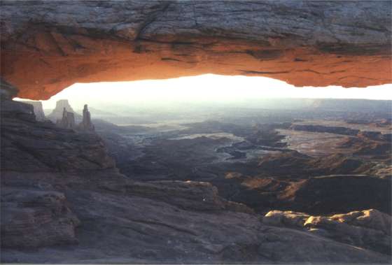
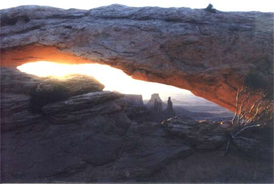
Monday 6/26/00 A marginal few raindrops to suggest closing car top and windows produced urgent stirrings just short of morning twilight. Guess it’s time to drive to Canyonlands NP, Island in the Sky section to insure a campsite. They are filled by 10AM per Arches NP rangers. Most unexpected, the Honda was just visited by a hummingbird while waiting for the opening of the Canyonlands visitors center. The hummingbird checked out all the Honda’s windows in this scrub-growth dessert environment. Ok, so there’s a pair of small rabbits as well. Plus there’s the lunacy of a chipmunk. 9:08AM at Syncline loop trailhead is a two-car space staging area with picnic facilities and more parking just behind. The gods must be with me, it’s a late trail start if beating mid day heat is a priority, but it’s overcast and cool enough for an 8-mile jaunt. The big question is taking raingear. Didn’t plan for this. Unpacking the Thule car-top carrier to get at squeezed in Grand Canyon gear isn’t on the touring list. It’s cool out and getting cold easily is a byproduct of body build. Heads says take a chance and go without raingear even if it seems daunting. Tails wins without the coin toss. Too much of a coward to face perhaps two hours rain-soaked on a cool day. Opted to carry the sunscreen just in case. It’s dripping the same rain, insufficient to get you wet, that was morning’s wakeup stimulus. Stepping out of the car, the first real rain arrives as more than just a sprinkle. A solution to indecision is; switch to hiking boots in case it gets slick and use a a collapsible tote umbrella. Don’t laugh. It will work. 9:30AM the hike ensues. Having arrived this morning at the visitors’ center an hour before the rangers is likely the cause for what follows. He, the ranger, definitely said crater. Succinctly came 8-mile loop trail. Being willing, the likely conclusion is a moderate hike of this distance around the rim. Hopefully the ranger was doing his job well and had sized me up first glance for an athletic young buck, full of youthful energy (at age 55). Being a self-perceived non-hiker, no mention of implied difficulty had been generated; none discussed. As a loop trail your choices are clockwise or the other way. The arbitrary decision was clockwise. As the trail made a gentle case suggesting a descent, thoughts of "up first is preferable to down first" ended quickly. An eighth of a mile in produced more wind and rain than a tee shirt, shorts and umbrella was comfortable with. Plan B to do the 2 mile round trip to an overlook evolved quickly. At a quarter mile, still on a negligible descent, the rain and wind abated. Ahead, now in view, the reason for the hike took shape. High canyon walls across a wide chasm, typical for the area, precipitated questions self answered. No way they would direct the trail over there. Correct, the trail is not crossing this deep gorge but it can descent into it. The descent starts now. Still puzzling out a moderate rim hike it was obvious the steep descent couldn’t last. Thirteen hundred basically vertical feet with only a couple of minor boulder scrambles does not constitute a rim hike. All the way down it seemed unlikely the trail would go the distance. The climb out will be unpleasant. At 3.5 miles in, having walked a long time on a gradually descending wash, a park service signpost provided the bad news. There were 3 miles to a dead end that way and 4.8 miles to go on my chosen path. Should have looked up syncline before starting (syncline trail). ("A fold in rocks in which rock layers dip inward from both sides toward the axis.") The Syncline trail now gradually ascends from the confluence of two washes that combine for that 3-mile dead end run toward the Green River (6-miles round trip). Up the wash not yet traveled, umbrella rolled up in one hand, the pace quickens. This is going to be a long day. Hope this direction is a steep descent and gradual ascent out. A 30-foot high dry-wash pour over is evidence of where many have been fooled before. The trail seems to go in a circle up a steep hill and down into the wash just short of the pour over. There has to be a way up and over it. Having picked up a set of one-direction footprints clearly delineated in flattened post rain-wash surfaces; it was clear the creator had continued forward. Yet the kerns seemed to circle. A sudden change in direction to a vertical rock scramble up 20 feet from the highpoint of the former circling trail could be easily overlooked. Atop the pour over and traversing flat again the logic was continue up the wash. But the trail seemed headed out of the wash toward an alternate very steep high climbing notch. How are they going to get us out of there? Some ups and shallow downs bearing toward the notch revealed a promising opening to the right. This opening was not to be, the notch and up was. Much vertical trail mixed with boulder scrambling, then the view back became impressive for what had just been accomplished. There were a few fear-of-heights moments for those inclined that could be dispatched by concentration on continuous movement forward. Suppose the ranger had been wrong about "the athletic young buck". Some of this trail’s offerings would be hard on a general hiker and difficult during a sunny day, perhaps dangerous if short on water or energy bars. Yes it gets you up close and personal with the terrain but unless you’re in for the exercise stick to the scenery easily acquired. This was one tough hike. The positives were taking the clockwise direction for the 1,300-foot climb. The weather was god sent. The 7-mile Arches NP Devils Garden push, a beginner’s trail next to this, was just enough stress on tendons and ligaments behind a non-hikers knee to add the resilience needed here. The pounding of a long descent, the aerobics and muscle needed for the ascent, the normal heat would be painful at best for an intermediate hiking body. Plenty of accessible water, hiking boots, energy bars and flashlight have been basic travel companions. The boots were a must here. At hike's end and hiking ignorance, two basic questions asked of rangers returned, "it’s considered a 7 hour hike classified as strenuous. To an indication of 4 hours and 45 minutes completion time the responses were good time and you must be in good shape. Adding an hours grace for a cool weather advantage and a required Cliff energy-bar stop, hope this implies preparedness for the Colorado. Tuesday 6/27/00 Up at 5:30AM to be at Mesa Arch 1.5 miles from the campground for sunrise per a queried ranger’s advice. A definite yes, you’ll get sunup over La Sal Mountains with strong canyon shadows much closer in the foreground. Though heavy scattered clouds blocked the event this morning, the results were worth the wakeup call. The ranger failed to mention the return trail (one mile round trip) has an approximate 200-foot section looking past Pinion Ponderosa pine at frontally lit canyons. These views were worth 2 hours of chilly morning air. The day’s plan is an easy day staying out of direct sunlight. Present location is a much-unappreciated Shafer Trail viewpoint roadside pullover with great advantages. It may be the only place you can sit in your car and see canyon structure lit from the back on one side and from the front on the other. It’s a small innocuous pullover. No one stops for more than 5 minutes. Some barely get the car stopped. Most of the time you are alone with a gentle cool morning breeze. It’s many miles round trip to Moab, laundry, hopefully a bath, water (there is non available here), town sightseeing, spare hydration bladder purchase and back here this evening for sunset. 11:30AM and it’s allready been a fabulous commune with the canyons day. 5 Canyonlands NP (Island in the Sky section) General Impressions
Attractions are generally viewed from a high vantage point accessible by car and short walk. The views are Grand Canyon rim like with a more intimate feel due to shorter distances. Best location morning and evening is the ½ mile walk to Mesa Arch. If the light is right it’s a zinger.
The park, late June, is far less trafficked than Arches NP. It is also cooler sleeping out. There are lots of evening bugs that disappear in the night air. Expect no facilities or water, just a small campsite, picnic table and covered pit toilet. 6 Canyonlands NP - Needles section Wednesday 7/28/00 After sunrise at Mesa Arch in the Islands section of Canyonlands NP, this time with a camera in hand, headed for Canyonlands Needles section 110 miles drive away. Arrived at the Chester Park loop / Joint Trail and Elephant Hill trailhead at 12:45PM for an 11 mile hike. After a stop in Moab for lettuce, tomato and block ice, a small breakfast and no lunch this was decidedly a two bar hike. That’s two Cliff chocolate chip energy bar hike. It’s not what the name implies. Instead, the ingredients are what your mother wishes you’d eat. They are not sweet, taste good (when hiking) and get the job done. This was a tough haul more for distance and heat considering it’s far from level. If you’re drinking water it’s likely not enough. You need to push it down constantly. Of the two Canyonlands sections, my choice is Needles, no contest a much more inviting physical environment full of its own preference of basic colors. You could do just the 6-mile Chester Park Viewpoint hike that doubles back over its route. Both trails retrace this section. Chester Park Viewpoint has most of what the joined trails have minus some interesting cool and narrow walks between mega blocks of stone. Do not start either hike if not in reasonable condition. Absolutely do not continue on the Joint Trail if you're not feeling great. The extra 5 miles will be unpleasant. 70 ounces of water was consumed after having tanked up ½ hour before starting. It was still good to have a reserve bottle if needed. The last 3 miles were water force-fed. Met a man shaded by a Pinion Ponderosa pine tree at the Joint Trail crossroad who considered himself a fast hiker. We couldn’t compare times because our start points were different. He felt the Park Service times were short. Two women, hikers in the flesh, didn’t. Eleven miles accomplished in 4 hours 45 minutes left little to consider an additional footstep. Agreed, Park Service time of 5 hours + is short or assumes hard-core dessert hikers. Having been at the gym and mountain biking for months I’m likely properly cooked. I’ll find out if I hike with Curt during the Grand Canyon trip. You know, the one stride for my two, body in mediocre shape, leave me in the dust going up hills trip organizer. Thursday 6/29/00 Up again at 5:30AM for sunrise opportunities after several nighttime wakeups perhaps due to one circling buzzard (mosquito) that couldn’t quite be echo located for subsequent execution. Did the best possible photo op with some cloud cover sunward. Now that it’s over, guess it’s time to get into photography enough to at least clean a very dirty lens and polarizing filter. It might also help in using some of my photo technique knowledge if I reacquaint myself with how to take the various camera functions off "auto". Time to read the manual of a rarely used camera. Been sitting in a closed car to keep out the bugs at a roadside get-out-of-the-way spot chosen for pictures while making notes as the sun rises further. It’s getting warm in here, time for the scenic drive before returning to camp for clean up and making plans. Definitely no long hikes today. The question is weather to move on or stay. This sure is pretty in the changing light and cloud shadows. With very little roadway and only a couple of roadside viewing points plus some well chosen roadside get-out-of-the-ways, this is a place to choose your hang out spot or hike. Enjoy the drive to and out of Canyonlands NP, specially the Needles section. It rivals the Park. Glenn driving 10 mph below the 55 mph speed limit should give an indication. It feels like a mistake leaving after one day but hike or leave persists at a time when not hiking today is likely best. Departing pesky bugs, needing a day off from hiking and the beckoning of Monument Valley at sunset as well as sunrise is a strong incentive for road miles. The car is in motion. Michael Jackson’s Thriller makes a great counterpoint to these hills. It starts with wind and a creaking door. Just outside the park, during this trip with no large animal sightings, it’s joyous to see the second coyote trotting across the Needles access road. 7 Canyonlands NP - Needles section General Impressions
A hikers place with colors inviting your mind's eye it’s worth the trip. My preference of these two Canyonlands NP sections would be here. However, if hiking is not on your mind, there is little for you here. Monument Valley 4:20PM
Accept some inside information. There’s a campground inside this tribal park, $10 for a tent site. Pay the $10. There’s water and pay showers in a run down but clean facility. (FYI: Your tent better withstand real wind.) The best part is you can have a front row seat at tent sites 24 or 25 with runners up 57, 58, 55 and 56 squeezing out 59. The prime group campsites are 26 and 27. You have real advantages. While others are trapped in their air-conditioned cars touring the valley below at mid to late afternoon, temperatures perhaps 10 degrees hotter than at the visitors’ center and campground, you can relax in the shade of a canopy at a picnic table waiting for evening or sundown. An impressive part of the valley is before you. The Park opens at 8AM. You can be taking pictures from camp at 6. It’s "Monsoon season" here. The more than a shower rain that is starting occurs once in three-years. With poor planning, as in it seemed like a good idea at the time, setting up a tent for the first time this trip became problematical. The wind picked up so strong the tent took on the appearance of a kite stretched off the end of one hand during an effort to stake it down. Two unsolicited neighbors determined a rescue was appropriate. They held fast, I drove spike. With 98% complete it began to pour. In the end the car provides a better evening, night and morning view. Tent practice makes perfect even if it’s not likely to be used on the Colorado. A lazy afternoon at a campsite with a world-class view equal to the best can’t be beat.
Friday 6/30/00 What’s it like to wake up in "the realm of the gods"? No different from others. But it’s great to be able to enjoy it. Things like a man made campground and general clutter fade into unimportance. I am struck by a people, local Navajo, who continue to struggle for existence in the awesome presence of such surroundings. It’s a puzzlement that culture alone would seem inadequate to explain. What have we other Americans done and continue with that contributes to such poverty? Perhaps in the end it is style rather than substance. This environment could never support more than subsistence. "American basics" such as running water and electricity are still luxuries here. Native culture, greatly impacted by ours, has been forced to reflect an existence less in tune with the land than their ancestors, thus a poverty impression. If with sheer will, Native Americans remain here with their ancestors, religion, culture and effort to honor the land, it will take creative genius to advance, in our terminology without loosing their roots. With an American culture that has difficulty honoring even the present, perhaps helping to engage creative genius is where we currently fail if we have an obligation to peoples we’ve displaced. This morning has a cool breeze, almost chilly. Today’s "job" is to explore the valley and figure out where to sleep tonight. Sunrise was super as was last night's sunset in spite of, or perhaps because of general heavy cloud cover. 10:30AM at a valley viewpoint The day’s doings: One more sunset and sunrise here is assured through reserved campsite 24. After 3 hours at one location looking back across the valley’s monoliths toward the visitors’ center, it’s hang out at site 24 from 2PM until after sunrise tomorrow. It may seem a strange day but watching an everchanging landscape-painting, courtesy of clouds and shadows highlighted by changing sunlight angle, is one reason for vacations. Beach lovers would agree.
9 Monument Valley General Impressions A must see that should not be missed at sunrise (sunset is also good). If the gods bless you, they will make an awe inspiring site even more spectacular for your mantra.
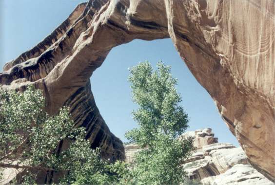
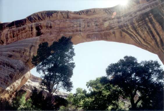
Saturday morning 7/1/00 Last evening’s exciting weather-phenomenon-generated Monument Valley scene would at best be difficult to describe. Suffice to say it was outstanding, heroic, and mythic. This morning an alarm set accidentally for 3:30AM instead of 5:30AM for sunrise, opened both eyes to starlight. A little more sleep, then sunrise and it was off to Natural Bridges National Monument. Natural Bridges NM is a quick stop, a nine-mile loop-dive with 3 stone bridges. Hikes are two flavors, bridge to bridge or they descend approximately 500, 400 and 300 feet from the loop-drive into tranquil intimate oasis of quiet, comfortable and cooler surroundings; a good environment to chill out in. Campsites near the visitor’s center are provided with pit-toilet service only. An honor system water limit of 5 gallons can be acquired at the visitors’ center. If you want more from this place you will have to hike early or late for associated sunlight effects. The visitors’ center display is inviting, informative and to the point. Well done. Better gas up in Medicine Hat on the way here. It’s going to be a long hall for more (95-miles). 11 Natural Bridges NM General Impressions
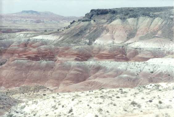
It’s a small place among low growth trees in an arid climate. The view of 3 stone bridges from overhead viewpoints is little more than a yawn. The more spectacular perspective of these natural stone bridges is from their bases. It would be better to visit only one bridge from the level of the river that carved them and spend some relaxing time along the riverbed than to scurry by at the driveway level. You could get some quality quiet time if only for an hour or two. You could also hike to all 3. But leave yourself more than half a day as I did. Saturday 7/1/00 mid afternoon Beside Lake Powel at a two-car length pullover with the lake down an unobvious 20-foot incline, there’s a very warm breeze drying my hiking cloths. I would have let it dry me as well but modesty is best back at the car. Washing salt sweat and sunscreen off always feels good. Had to veer from my original planned route across 68–mile Burr Trail, an unimproved road. The rangers at Natural Bridges advised against it in a standard clearance car. AAA states my current drive along highway 95 and 24 is a scenic one. Agreed thus far. The colors of the rainbow would be hard pressed to outnumber the various changes in terrain traveling 95 and 24. Jagged mountains, flattop mesas, differing forms of rock and many types of sandstone, they are all about. Tonight’s "campsite" is courtesy of a ranger at Natural Bridges. According to him, there are many places in Dixie National Forrest to just pull in and set up for the night. It’s only 7:45 PM in the middle of a jeep or wagon trail that sees rare use. If lights show up tonight the Honda will have to be moved. There’s no driving around it. Among the smell of a Ponderosa pine forest somewhere high up is a break in the trees that oversees a new trip’s-environment and another amazing view. Below are scrub-growth covered mesas. In the distance it looks like barren pail sandstone. Beyond that is too hazy to make out, but the view when clear must go a very long way. Being prepared for self-sufficiency allowed for this happenstance stop. The sun is setting behind the mountain underfoot whose summit may not be much higher (Boulder Mountain). Hope this means sunrise is somewhere ahead. Think I’ll set up the car for tonight and take a short stroll down this trail before the light fades. The trail belongs to no one. It passes through beautiful white Aspen and Ponderosa pine woods then fades into the forest 1/8th to ¼ mile behind the Honda, which faces a backup-turn switchback toward the highway. At one time this trail went ahead as well. Following it a short distance takes you to a location overlooking a noisy campground 400 feet below. Though very short, these have been the first cool temperature walks so far. It may get cold up here tonight. Far off in the distance, too far for sound, is a lightning storm. Good day’s end. Sunday 7/2/00 With eyes available minutes before the sun’s bright orange face, it’s a get up comfortably chilly morning. A few thin scattered clouds and a 5 to 10 mph constant breeze outside the Honda make a slow impetus for morning wash-up, teeth and shave. With temperature and breeze combining for slightly numb wet fingers and face, shaving is a careful pursuit. Perhaps it’s the ever-rising sun or the eminent car’s shelter, but one windbreaker fleece vest has done it. For the record, it was a two fleece blanket night, though according to the North Star, the sun rose NE. Should be at Bryce Canyon an hour before they open the visitors’ center. Dixie Forest’s Boulder Mountain has some overlooks worth a stop but they are afternoon and evening sights. If you’re driving Dixie’s route 12 at night, beware; this is open range country. A steer or deer may adorn your hood. They are both plentiful enough to be a risk. Distance miscalculation: It will be an hour or two after opening at Bryce. Blew through Capitol Reef NP yesterday late. The visitors’ center was closed so there’s no information. It looked like hiking mesas country. Now, just short of Escalante, NM within Grand Staircase, NM has brought a 70 mph attempted pass-through back to reality and a pause in the morning light. Barron, slightly gray, cream colored massive solid rock hilltops are pockmarked with tufts of tiny trees. From this elevation it is an expansive view (Hogback-narrow ridge – 1940 automotive mail service route to Boulder). The plaque says, "As you drive over the narrow ridge of the Hogback, it is easy to imagine that you are walking a circus high wire." They got that right. Any wrong turns here are downers on either side of the road. Don’t barrel into any of the abbreviated gravel pullovers. It could be your last act in life. Thankfully the short 8-foot wide rental RV changed its mind about pulling in behind me. Thank you, thank you, and thank you! He picked the next pullover 40 feet ahead and left some of the vehicle still in the roadway. He could have pulled all the way over with his wife in cardiac arrest. This is the direction to be headed on this road since it has the pull-offs. A plaque further along route 12 reads "On a clear day you can see forever." Even in some haze, Boulder Mountain now 30 straight-line miles away, looks to be just over there. "Boulder Mountain sits atop Aquarius Plateau. It is the highest timbered plateau in North America, with elevations exceeding 11,000-feet above sea level." Further down the road, Escalante appears to be an entire small town in the process of a major face-lift. It may become a fun tourist stop. The last miles into Bryce begin with sandstone that’s almost peach color and looks like an effort to create a castle by dripping sand on sand at the beach.
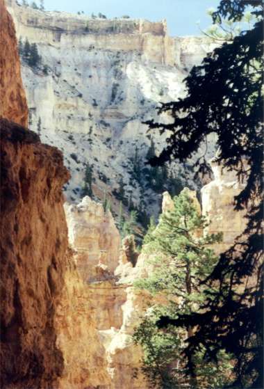
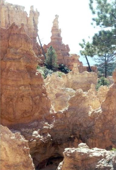
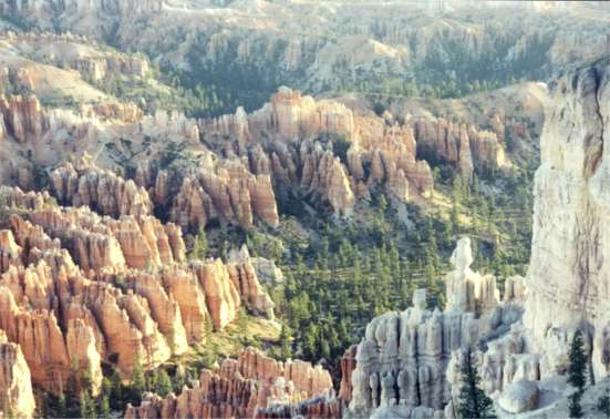
Bryce – first impressions: This park has organization disaster written all over it. Before you get to the visitors’ center you have the park’s shuttle bus service with a parking lot arrangement that makes every car consume gas via the longest exit route available. This stop is also useless if you intend to camp in the park since you must drive in, to get to the campgrounds. Parking is so limited at the visitors’ center that musical cars are the rigor. More polluting fuel is in the air. Shuttle busses, begun 3 days ago, are frequent but diesel? Campground entry is total confusion. Pick a number and register before you enter or drive in confused by loop A, B, C, D each intended for a type of use (vehicles over 20-feet, short vehicles and no generators). So you drive in to find your site and get lost trying to figure out how to get back to the registration board. Hasn’t the parks service figured out yet a picture is worth a thousand words? Haven’t they learned to put simple, obvious signs at junctures? On the other hand, Bryce has monstrously beautiful and inviting colors both subtle and bold in a complex repetition of forms and patterns interesting to the eye. Ok, the warning’s been given. It could get down to 40+ degrees tonight. Think it’s time to pull out every warm thing in the car. May need something for the 9 PM ranger talk. Crud, it’s unpack the Thule. Inside is the only windbreaker. Monday 7/3/00
Colors, light and shadow glow here. Reflections flow with repetitive joyous abandon. Trails, once you have licked finding trailheads, are easy footing hard pack. Though most, perhaps un-surefooted, seem to gaze down; it is possible to walk with head up to take in all the eye candy. Just check where the trail is regularly. Some missteps would be a long way down. There are some fear-of-heights issues on some trails but perhaps concentrating on the trail ahead can compensate these short stretches. Monday 7/3/00 hikes
Hiked all day; Navajo trail to Peek-a-boo to Queens Garden to Sunrise Point and back to North Campground was the morning run. After lunch, hiked the Rim to Fairyland Point to Tower Bridge, back to Sunrise Point and North Campground. Add in miscellaneous and the total ground covered today was 15-miles. This is not recommended if you’re not feeling strong. Lots of ups and downs await. Keep your water battery charged; you’re at 8,000 feet. Wear sunscreen, the light is intense. Tuesday’s plan is up early for sunrise photos then hit the road. The easy, short rim hike yesterday with ranger at 5 PM was informative even though played down for the younger set. The 9 PM ranger hijinks slide show adjacent the campground was likewise. I’m whipped from today’s excursion but not so much to miss a shower and laundry. It’s windy. Perhaps campers will quiet down early. Tuesday 7/4/00
Bryce Canyon remains true at dawn. Its subtle and bold beauty is around you all day. Watch it develop from any location, still or mobile afoot. 15 Bryce Canyon General Impressions
A must see place in spite of the 1.8 million visitors annually. There is eye candy everywhere. So hikes are not a requirement. They do cut down on the crowds. Low angle light is an advantage for colors but not necessary. Overcast may do just as well if you’re lucky. Button down your hat, it can get windy. Chilly to cold nights are a reality after sunset in late June. Schedule ½ day to get acquainted. Bryce is inadequately signed and poorly organized. The campground is sectioned to get you away from RV generators. The men’s washroom had one sink. Outside dishwashing and water spigot are provided. Showers and laundry are at the general store a short hop from North Campground, which is just passed the visitors’ center. This campground is a good staging area for hikes. You can leave your car and skip the shuttle buses just begun 3 days ago. If you’re just going to overlooks, take the shuttle and leave the parking hassles behind. 16 Cedar Break National Monument
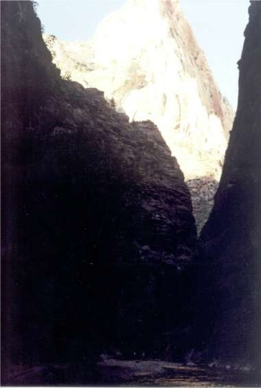
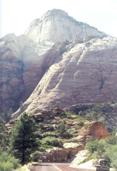
Cedar Break National Monument is a very small less complex version of Bryce. With limited hiking, it is colder, windier and approximately 2,000 feet higher at 10,000 feet plus. It’s a late get up place with light coming over your shoulder to arrive in the canyon around 9 AM. It’s 48 degrees and windy. Perhaps from the sun at almost two miles above sea level, the cold in this wind is not intense. There are no crowds here. The light here at 9:30 AM is so crystal clear it makes everything seem more defined. The descent of route 14 to Cedar City is an ear popping 4 to 5,000 feet. Gear down or have good breaks. July 4th, courtesy of Cedar City at 10 AM, route 14 is dead stop until they Finnish with their parade. Tuesday 7/4/00 Zion NP I-15 exit 40 to Zion’s Kolob Canyon is at the northern end of the park with no roads connecting to the rest of Zion. The drive in for viewpoints is short. Camping at the southern end may be hard to find tonight per the ranger at this visitors’ center. At the southern end of the park many miles from the Kolob entrance, Zion, from a roadside viewpoint by car or shuttle bus is a canyon cut by the Virgin River. It’s a place of impressively massive vertical sandstone mountains and cliffs in two main colors, rust and gray beige. Impressive as in cliffs 2,500 to 3,000 feet are climbed in two days. Think of a 125 to 150-story industrial building. Of course there aren’t any today. It’s impressive, even domineering if you find a summer-shaded scene. Impressive, a geologist’s and climber’s treat. Yet it seems not to inspire. Perhaps its beauty is subtle and elusive. It brings to mind the phrase, "How are you going to keep them down on the farm once they’ve seen Paris". These cliff walls are no match for the high cliffs of the Grand Canyon seen from the river. They lack the size breadth and complexity. Morning and evening here bring the glow of reflected light. "Having an off day?" you may be wondering. There have been a few stumbles, but what would pick up a paddler’s day? Take the shuttle, which follows a canyon cut by an "R" word, a gentle gravel and river-rock flow when not in flash flood. A mile and a half up a tree shaded, easy walking paved path and it’s river sandals time. Many do it. Few have the equipment. 300 yards up and you’ll get your shorts in water as the canyon closes in. The Narrows may be tomorrow’s challenge attired more properly in synthetics. There may be some other short look-see jaunts as well. A ranger said you have to take some long hikes to get to the good stuff. You would need inspiration for a 2,100-foot elevation change 8-hour hike even if you were likely to do it in less time. The 3,000-foot hike up from the Tatshenshini River, Yukon, Canada was worth it. The lofty views available here are already in the mind. Putting the energy for this one in the bank for the back side (other than straight vertical side) of El Capitan some day seems a good compromise. If you bring a bike, you can stop where you want along the shuttle bus route and if pressed for time, might even outrun the bus. Cyclists have passed in the opposite direction on occasion. Their freedom is likely the next best thing to a hike for getting to know the place. Wednesday 7/5/00
Spruced up and on Zion’s 12-mile main road by 7:25 AM for a morning-light view, nice rock. A minimum 10 mph continuous breeze and cool temperature is incompatible with a river dip hike.
The shuttle bus route is more interesting in this light. A 2-hour easy hike to a 90-foot waterfall from Zion Lodge is not compelling. They also have a paved short "mountain bike" trail along the river. So, here atop a boulder looking back down a 20 to 30-foot wide canyon between two one hundred foot high walls, the question is why. Having perused the park’s newsletter for an early day’s quick excursion, Weeping Rock sounded good. Having missed the fact that ½ mile meant round trip and also being at the trailhead for something called Hidden Canyon, a mile one way, the choice was obvious. Newsletter information in the car back at the visitors’ center and with nothing else to go on, the game was afoot. A mile later, up a continuous 25-degree heart-thumping switchback, paved to look like a rock trail, you get to a sign that says strenuous trail ahead. Correction, the last 1/8th mile is not paved. It clings to the side of the mountain rock-face with an embedded chain grab rail for those concerned. Slick rock mixed with a little fine sand tracked in by hikers, a one-person wide track and steep drop off has you wishing you were Spiderman. And now they talk about strenuous. The sign, by the way, is about 20-feet away. To get to it and Hidden Canyon, you must negotiate a sloped rock surface that is inclined to deliver you into a small pool 10-feet down from which there would be no exit without assistance. The fact that this slick-rock also has hiker born sand is no help. Strenuous is not the issue for perhaps a half-mile into the canyon. Some places called dangerous would be more to the point. Continuing from the present location would be foolhardy solo. Needless to say, there is no sound of anyone else in here. Only tracks in the sand of others not deterred by "no" and dumb enough to have continued. Slick rock, sand and falls with quick stops are not a comforting thought. Think today was not the best for having no breakfast. Enjoyed the walk in here, mostly flat on a prehistoric streambed now covered in sand and some river rocks. After a few rock scrambles you’re finally stopped by the thoughts of an earlier comment about people climbing to heights without knowing where they will put their feet during the climb down. Don’t intend to make that mistake. There is a fabulous glow off the walls in here along with plenty of greenery, trees and low growth for comfort. Exit time down 850-feet and past the gathering crowds, many of whom will not ascend to the trailhead. Listened to shuttle driver Mike Shannon provide a combination of enjoyable, detailed and informative well-chosen sound bytes. On the way out of Hidden Canyon, about 40-feet before retracing the slick rock "entrance fee", I spoke with a couple also crazy enough to have paid the tariff of fear. We swapped go to places. Their tale of squeezing through narrow cracks tracing the sinuous path cut through rock by a flash flood corridor in Escalante is one to put on a future list (Escalante slot canyons – Brimstone, Spooky and Peek-a-boo on lands manages by the BLM, information at the visitors’ center in Escalante). Be aware of the weather for obvious reasons. Back at the Zion visitors’ center to see if there are any ranger provided geology walks or lectures. It’s become apparent that despite huge size and implied grand vistas, the real story here is up close and personal with the rocks. After a ten-minute conversation with an ex-New Yorker, ranger and a specific request for information about a bagel, the answer was a "café" called Watchman’s in Springdale. It’s a small, half take-out place with coffee, tea, croissants, bagels and sandwiches based on the above. Some serious personal energy recharging followed this stop. The location was a picnic table next to the nature center just inside the park. Ham, Swiss cheese and eggs on a whole-wheat bagel went down like an hors d'oeuvre. Some water, movement limited to the table, the question becomes; is it near enough to 2:30 PM for a 25-minute talk on geology? Or is it hit the road? The organizer alarm says ½ hour to go.
The drive in is not exceptional, passing through a few small towns until Springdale, a larger small town, also a tourist location. To their credit there are no fast food places. Springdale is adjacent to the park entrance. The park feels well groomed. It’s an impressive place but seemed not to excite the mind. At 7 PM, a long way down the road after Zion geology 101, there’s a gentle, almost cool breeze flowing in Kaibab National Forest. The distance is about 40+ miles to the Grand Canyon North Rim and ¼ mile deep in the woods away from route 89. Take a smooth gravel road unmarked on route 89, select logging access 200C, back into an old spur and you have the sound of trees in a breeze, no camper noises or lights. You get the feeling of having traveled far into a Ponderosa pine forest scatted with Aspen. Add the music of John Williams and the London Symphony Orchestra just for added ambiance. This is amazing, quiet and beautiful. The light plays at a steep angle through the trees. Based on the temperature at 8 PM, it will be chilly tonight. Thursday 7/6/00 Another face and hands numbing shave and shampoo this morning. It’s chilly at 7 AM with crystal clear light glancing obliquely off tree trunks and pine needles. Even the Honda took an extra crank to get up. Found out at the North Rim park entrance it was 46 degrees last night. Sitting at a picnic table overlooking the canyon from Vista Encalantda viewpoint it is hard to believe it’s been a busy day. Drove 40 miles, entered the park, waited at the campground 1-hour for the registrar to arrive and had Michael Root and family offer to sell me their campsite. They were headed off on other adventures. Knowing there would be a site available by arriving this early and at ½ price with the Golden Access card, declining seemed the choice. Mr. Root tracked me down during an ice block purchase in the grocery store at the campground entrance. "You take it and enjoy". He wouldn’t accept money. Seems he does some paddling himself. Must have spotted the canoe. Did the dumb tourist thing and drove to the farthest observation point figuring there was time to get back for a ranger conservation talk and walk. Not fully appreciating a 35 mph speed limit and the pace of a sports car lovers twisting road, ran literally to the North Rim edge, an additional 5 minute walk one way and then ran back to the car for the 30 mile round trip drive in time to catch the ranger’s start up. The ecology talk mostly involved discussing how fire effects and is part of the natural cycle of the North Rim plateau. Approximately 50 years of fire eradication has changed to a policy of controlled burns in recent years. This was the hot topic because a recent burn and freak 80 mph winds equaled a year’s worth of spot burns in one fire only 4 weeks ago. The follow-up ranger walk was cancelled. The trails usually used were not yet open post fire. Now, with a time-whole in the day’s schedule, the realization that bouncing between viewpoints was driving-intensive and hiking not on the agenda, a lazy afternoon setting up the "camper" was in order. That done and evening approaching it’s time to find a parking space at The Lodge to gain a ranger’s incite about the Grand Canyon suite by Grofé, (Ferdinand Rudolf von). Next was a ranger lead look at the night sky via the rim. Could have skipped 3 of the 4 ranger talks today. The geology, early afternoon at the rim was good. At 10:30 PM after the night sky talk 3 miles away; it’s time to tip tow, with headlights ablaze, into the campground. Friday 7/7/00
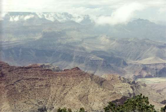
Up at sunrise again. Do the sports car slalom thing to Imperial Point because this wasn’t planned due to the late evening antics. Be aware, the park Smokey will ticket you, just figured he wasn’t up yet. Pictures, it’s nature, you just have to catch the old girl when she wants to show off. At 10 miles rim to rim, haze is the norm. On a clear hazy day you can make out the tops of high mountains over 120 miles away. Clean up back at the campground and off to Lees Ferry, our Grand Canyon put-in with questions for the ranger.
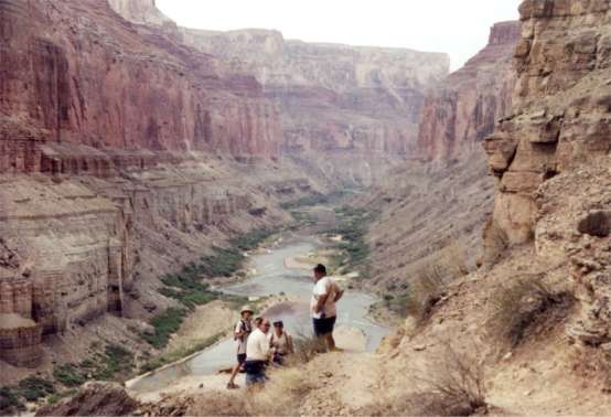
21 North Rim General Impressions Glad to have gone. It was a different and in some respects more interesting view than the South rim. You’re 1,000 feet higher for a different perspective than the South Rim of 6 year ago. Hiking is likely the way to enjoy the ecology and views. The Lodge here has the best drive-to viewing location so step right through to the outside stone terrace. They don’t charge for this. Lees Ferry and ranger Ray Hall would be happy to accommodate an arrangement to lock up our canoes a day early back of the ranger station. Oops, he won’t be there on the 11th. Due to personnel changes he doesn’t know who his stand in will be. He will give us a check out and orientation on the 10th if we can get equipment and everyone ready by midday. Lees Ferry has changed in 11 years. It now sports a real parking area, more refined infrastructure including a cold-water washroom. There’s a Navajo Bridge Interpretive Center, a tad short on interpretive, at a new second bridge crossing the Colorado at Marble Canyon. The old bridge, barely wide enough for two vehicles passing opposite each other, has become a footbridge for viewers. Glen Canyon dam had to be seen; it’s the control source for our river flow, besides there’s all that technology to wow over. After the 45-minute tour, it wasn’t all that impressive. A 186-mile long man made lake behind some concrete falls short. After an hour or two of what the History Channel can do to tell the Hoover Dam story, the almost nothing moving but the 50-story internal elevator isn’t video game enough to retain interest. The stats are impressive. 24 Lone Rock "campground", only a few miles from the Dam Having fumbled the ball at this juncture of the planning department, sitting in the "hot mode" praying for a cooler evening at Lone Rock "campground" beside Lake Powel is the only game in town. This beach is a free-for-all 1/8-mile-long waterfront minus ocean waves and salt. It does have boats and personal watercraft everywhere. Did someone say beachfront? You can’t see it for all the RVs, boat trailers and people making whatever noise elevates them. Off to one side where you would have to pitch yourself off the edge to get to a dry wash ending at the lake are three quietly parked vehicles. One’s currently empty. We’ll see. Thankfully it’s been overcast above this part of the lake all afternoon. The mesas that are highlighted around 5 miles away have had those bleached adobe colors. A dip in the lake, envisioned from a previous day is out the window. It may be time for the next best option now that evening sunlight has arrived, pay showers. Dumb and dumber, if it looks like Virginia Beach where they roll out 4x4s and RVs along the shore, are they going to have pay showers? No, they’re going to have push-the-button and get cold sprits outdoor body and foot nozzles. Back to the car as the sun sets, on with the swim trunks, cold shower and drive back to a "secured" spot. Nice sunset to shower by with lightning in the far distance downwind over a mountain. There’s a just noticeable breeze now. Bare topped for the first time in a while feels like being part of the now more subdued party. If it stays warm like this it could be ground sleeping time. But then there’s some real padding in the car. This is not your soft beach sand. Saturday 7/8/00 Various noises continued until after the last hues of horizon-light quenched. Sound travels far out here. Friday night people arrived and "late" people packed it in to leave after dark. It was still quite warm but a perceptible breeze was enough for sleep.At the extreme end of this encampment this morning, listening to (barely audible) John Williams " Sound of Hollywood" in the twilight, it wood be hard to find fault, past a chuckle, with inconsiderate people doing their thing in such a beautiful and otherwise quiet place. Distances are so great. Surrounding mesas seem mere interruptions in the horizon. Sound carries so far the slapping of motorboats against the lake’s surface ½ to ¾ miles away appears just before you. Most of the camp is silent at 6 AM just inside the Utah border. The sun has been up for a half hour tucked behind clouds. Already there’s the sound of young women’s glee somewhere far off across the expanse of lake as they are towed at speed in an inflatable. The quiet couple near by have already folded tent. Their tiny car has gone to find today’s adventure. With a 5 mph breeze breaking any sense of heat's discomfort, this folding chair is taking in the scenery in the first slow get-up day of the trip with sun sparkling across the lake. Fascinating contrast between the distant sounds of boaters who’ve been up for hours and a quiet camp of many yet dormant. The big surprise last night was a sudden strange wind from an otherwise stillness. At around 20-mph it kicked up dust and had many campers scrambling. Some cranked up and skedaddled. A padded car for sleeping was a good choice. Five electric windows quelled a knee-jerk reaction. Twenty minutes later it was all over. A slightly cooler gentle breeze was the replacement. With a couple of small National Monuments scheduled for sometime today, possibly the South Rim tomorrow, I may just stay here this morning to repack the river cloths laid awry unexpectedly for these travels. It would be nice to arrive at the put-in with only one major job, unpack the car. Laughter at Americans; a hefty young guy, reddish from sun, shorts to the knees, beer in hand, swatting at something is determined to explore across the wash 40 feet away. You can hear every movement, every step, grunt and belch as he ascends the far side. "Pepper come here, now" ushers from an overweight woman a city blocks distance away. There’s little else from the rest of the camp at 8 AM. It’s a great beach type morning. Still no direct sunlight, just a warm and breeze-fine day’s beginning. Ah, the object of Determined’s efforts. You can hear it dragging nearer across the sand. Of course the empty beer can he just dropped requires only the effort of a muffled "Oh, shit", but the cheep plastic inflatable that got across the narrow wash inlet will be retrieved. More chuckles. It’s so great to be an American. We are so diverse and so benefiting from diversity while hating it at the same time. Have another chuckle. A thirties-something couple arrived in a business signed pickup with personal watercraft in tow, unpacked with discussions of bringing the dog "Those folks over there have three." Here come the folding chairs, canopy, cooler, water and barbeque. What’s hilarious, in checking my car out I have almost the same with a modicum of size. Possibly more environmentally friendly or less intrusive, it’s all there if you accept a camp stove as a barbeque, a canoe for PWC and a mini beach umbrella for canopy. Love this sit-on-your-rump morning, temperature and view just right. Food might be a good option about now. After putting a beige plastic tarp over the low commercial pickup-bed rack, it’s decided she will not sleep next to the spare tire. 130 miles later at the east entrance within the South Rim of the Grand Canyon NP, there must be many disappointed viewers. With real rain, though quiet at the moment, an influx of fog almost obscures the Rim’s watchtower only 100 feet away. At 1 PM, barely an outline, its image is scarcely a change in the luminous haze of mist around us. Found it, a place to camp for the night. There’s been one visitor in the first 5 minutes, a small, medium gray, pudgy bird with short sharp beak and Mohawk crown. Inching its way through small tufted evergreen needles, from branch to branch it pressed ever closer. Something new in it’s territory to inspect presumably. Heading west on route 64 from Cameron toward the Canyon you traverse the corner of Kaibab National Forest. We now know this means camp anywhere off of any unimproved woods road at least ¼ mile away from the highway. Do no further damage and stay on trodden ground. Six miles from the Canyon’s Desert View parking lot, such an unmarked road exits. Off an unmarked spur barely passable for the Honda, a clearing in the scrub trees is suited to the task; sleeping that is. The early afternoon haze (ground cloud) at the Rim passed and the Old Girl felt like showing off. High, lightly overcast skies allowed spot sunlight through. Clouds were adrift on canyon walls. With a cool breeze came relatively haze free viewing. Next step, hang out in a open sky, low tree forest, set up the "camper" for tonight and then drive back to Desert View for a 6:45 PM meet with the ranger for sunset viewing. Current sky prognosis says it might happen. Amazing, no sooner said than it’s prep time. Evening attire hung out off the roof rack on two plastic hangers, a quickly poured gallon of water into the sun shower to hang in the late afternoon sun and it’s arrange the bedding. Fifteen minutes later, with whatever the sun could do, it’s strip naked as you were come your original first light, wet down, quick soap, a rinse and it’s done, hair and all. These are not your squeaky cleans; they’re your get down to wholesome skin showers. Mark this road well. It’s easily passed in daylight (odometer 36.9 just passed mile marker 270). It came out as 7.9 mile on the odometer for the return. You would think the time zone thing would be worked out by now. It’s not. Missed the ranger meeting. But the trade off was worth it. The Old Girl (Ms Nature) must have heard us talking about her. She was kicking up her Saturday night party knickers. Forget pictures. Plenty of set-up time and the right equipment would just be a starter. Not likely to be able to adequately describe this, lets just attempt the background setting. The North Rim wall is straight ahead ten mile away. Like a very wide mesa the center half of the horizon line is slightly higher than to the left or right. The canyon in front of the horizon follows an enormous U shape with arms wide enough to be in your peripheral vision. Perched atop and fastened to that long flat North Rim’s horizon is one massive storm cloud repeating the "mesas" width and standing 2/3rds the Rim’s enormous height. It’s the shape of a knockwurst in a bun viewed from the side; with the bun centered on the horizon line mesa as though atop a cutting board while mimicking its width. The colors and textures are dark and ominous against a light blue-gray open sky rising above your head. Add to this remarkable chance symmetry the discord of scattered small clouds to the left in the narrow gap between the left wing of the cloud and the horizon. Here among these drifters the sun sets. Add occasional lightning for effect then paint your own picture of sunset colors under both wings of the storm. Have fun and enjoy. 26 Wupatki and Sunset Crater NM Sunday 7/9/00 Late 9:15 AM start from Kaibab NF. Hustled back out route 64 to the junction of route 89 at Carmen. Spoke with Bonnie via phone. Per Rich the outfitter will pick us all up at the Holiday Inn in Flagstaff on the 10th. That only leaves seeing Wupatki and Sunset Crater NM on the way to Flagstaff, both on the same loop off route 89 just north of town. Good, only 71 miles total driving for the rest of the day. Wupatki NM has several prehistory Pueblo ruins. Sunset Crater is a cinder cone version of volcano. Neither site is likely to excite you but both are interesting. Time to face the music. Having been successful in avoiding the trappings of modern American civilization for a while, going to a Holiday Inn doesn’t quite cut it. But staying out tonight is likely to be disruptive, at least mentally, for the Grand Canyon trip folks. Civilization can be delayed for one more 1-mile hike at Sunset Crater 6:30 PM with 16-miles to Flagstaff. Figured it out. It’s all that pampering associated with a large motel that’s disturbing, not being in a small city. Turns out having arrived at the front desk, no one is registered, no one has reservations. Bonnie said Rich called from Flagstaff at 4 PM. Guess everyone decided to camp out and meet at the Inn tomorrow. It’s late. After several wrong turns in town, headed back to Coconino NF which surrounds Sunset Crater NM. Though not easy in the dark, found a spot for the night. Monday 7/10/00 Spruced up and looking sharp from the usual morning clean up, headed for town at 6 AM in search of a Laundromat. Everything is dirty except for the fresh cloths for today. First Laundromat doesn’t open until 7:30 AM and SAM’S Club (need film) opens at 8. What to do for an hour? A drive across town’s route 66 equaling 3 short interstate highway exits gets you to Big McD’s for eggs and pancakes. Best to charge up the body now; it’s going to be a long day. A fast interstate run back to the Laundromat and it’s open a few minutes early. These are good machines, front-loading double loads at $1.50 per. The best thing about the cloths, including a sheet is everything goes in the white load or one wash does all. Wash dried, folded, bagged, out to the car and Rich and Linda pull up along side. They just attempted to complete paperwork at the car storage facility we’re using while on the river but found there wasn’t any to complete. They spotted my car on the way back. Seems John Flynn, another participant, had made all the room reservations, which all subsequently came out in his name. With rooms cleared of our things, the raft outfitter arrived with a Ford E350 15-passenger van, rafts and equipment in tow. With a brief stop at the car storage facility we were at Lees Ferry put-in by mid afternoon. In spite of careful planning and organization it still took until dark to set up the canoe and get everything stored in dry packs just in time to pull some items back out for sleeping. Tuesday 7/11/00 Put-on day From among the tamarack bushes adjacent the put-in beech and awaiting rafts a number of reacquainted voyagers emerged from sleep. Shortly a Park Service ranger arrived to check on required equipment, a toilet system etc. After an orientation slide show narrated by the ranger describing an ecologically sensitive Colorado River corridor, all preparation was over. We were headed down a river that had cut its way through the surrounding plateau. Today’s first serious challenge is Badger Rapid. On any wilderness trip, the first rapid is generally among the toughest because you're not accustomed to sluggish handling from the added gear weight. With this river general rules are caput. Badger may be difficult but we know it’s just a warm-up. The true challenge for us all is to begin to learn how to handle the difficult patterns and power of this flow. As we descend deeper into the chasm created by the river, though we follow the same water, the walls on either side rise higher. The river has found opportunity to cut deeper. A rapid called House Rock had lesser-experienced paddlers vacate the paddle raft replaced by more experienced folk. Many of these had walked back up river after their individual runs in separate crafts. The river narrows and concentrates much of its weight against the left bank within a river arcing to the right. Toward the end of the arc are two large boiling waves and a bolder further constricting the flow. I was the first to have a foot dislodged from beneath a raft tube. Hanging overboard with one foot still firmly in a foot cup my body was quickly set afloat following total submergence in the first large wave. As arms and legs adopted swimming mode, the second wave flipped the raft over so all could appreciate the cleansing effects of cold water in motion. Fortunately, experience kicking in, everyone held on to their paddle and we all struggled to force the raft toward any shoreline eddy. Amazingly, we succeeded. The consequences of the paddle raft adrift in the Colorado’s current could be simple or major. Reacquire the raft in a near by eddy or it could be a redistribution of its original occupants on the ore rigged support rafts while a "prayer" retrieval chase by hard boaters ensued. If the raft stayed in the current for any length of time, the distance traveled just while the group organized would mean a push and risk for the pursuers. With raft secure, a discussion of the cause revealed a flaw in the captain’s plan. Our entry at the top of the rapid had been spot on. An order to angle the raft left followed by back paddle sealed an overturn course. This maneuver might be appropriate on some tough east coat rivers but not in the Canyon. This river is merciless to relatively weak back paddling power. It needs the maximum effort of forward strokes. An experienced east coast captain gets a lesson in Canyon humility. Graciously, the Canyon allows all of us some time to get adjusted before the heaviest slam-dunks. Lesson two is a heavy ore rig is also no match for the river. The correct approach to each rapid makes the difference. Thursday 7/13/00 Day three Today started with a rapid right from the campsite. Rapids on your first stroke are always risky. The brain and body are both unfamiliar with their day’s response. Is the brain awake enough for complex patterns? How strong or quickly will the muscles react? All’s well that ends with only one hole to skirt and 4 to 5 foot curl crested waves. The group faced a challenge at Silver Grotto. It’s a short hiking distance up a narrow slick rock canyon with drops and small, shallow pools. The start requires a human ladder shoulder to toe up an eighty-degree incline over 20 feet high. We worked our way up the canyon one group problem at a time. Later we took a short vertical hike up to the remains of an Anasazi rock-wall building foundation. Next stop, paradise, a small stream flow of crystal clear water ushering forth through the canyon wall 60 feet up. With our filter hand pump, all water bottles and 6 of our 4 & 5-gallon water containers were full. Attempts to find a large nautilus embedded in stone failed on our last short climb for the day. We’re not sure why. Some of us found it 11 years ago. In camp at almost twilight the heat is still too high for sleep. We had a vision of ever multiplying mice last night as twilight enveloped us. The two-inch speed demon balls of fluff are a multi-level hazard. Possible disease is the first. Less subtle is their ability to locate food through layers of sealed plastic. Aside from food the destruction of dry bags becomes critical if too many become useless. We only lost one bag, which was likely hit before we moved all remaining bags to rafts or canoes. Direct sunlight is inching its way down the far canyon wall. Soon sunscreen goes on. We’re having a slow start morning considering the few extra miles planned. We made camp at Nankoweap, the site of an Anasazi grain storage ruin set into a cliff beyond the scree line approximately 500 feet above the river. The ruins are four window openings created by enclosing a depression in the cliff face with stone slabs and mud mortar. The view from the precarious trail in front of the ruins is panoramic within the inner canyon. The Colorado River turns before a high, massive, red stone wall to the left and in front of you probably a quarter mile away. It then wonders off to your right, sealed between walls that still look high over a miles distance.
Saturday 7/15/00 – 5th day The day started off overcast and warm. We’ve faced wind and large wave rapids that would be considered serious in the east yet are primarily scouted on the more here. We swam in the crystal clear blue waters of the Little Colorado River. During the trip 11 years ago it was so thick with mud the froth usually associated with river currents careening over ledges and boulders was unable to form. We are camped within site of the South Rim tower of the Grand Canyon’s Southern Rim. This is one of the few places you can see the river from the rim. Of course the distance is so great, people on the rim are unable to see us without a telescope or binoculars. They would also have to be looking for our specks along the river shoreline. The morning of the eighth day is quiet. No loud or even moderate background sound of rushing water. No rapid or riffles to moderate sound from early risers' movements. No early risers either. A mere zephyr breathes through wisps of thin green Tamarack leaves. One boulder just under the water’s surface turns the current into a low oscillating frequency punctuated by quiet splashes. It’s a simple reminder of power and speed. Into the future, perhaps a half-mile away, is a drone from something to come. At full dawn’s cloudless blue-gray sky, a golden patch from sunlight grows on the far inner canyon wall. It must be fairly late, yet few have stirred, perhaps a tribute to yesterday's late adventure. River guide maps do not recommend running Horn Rapid at a water level of 8,000 cubic feet per second. We have run some difficult rapids; this one stopped us. It was a test in river running safety. The process of working out a plan and executing it took perhaps 1-½ hours. We had to get a diverse range of crafts, equipment, people and skills past this obstacle. The challenge at the end of a long day of rapids and aggravated by strong winds could lead to mistakes with serious consequences. Linda at the helm performing some kayak ballet weathered the flow with grace. The destiny of each of our remaining crafts was formed through much study of the rapid by those most experienced in our group. Walking, though not an easy task across a boulder-strewn shoreline was the preference of most hard boaters. What remained was one paddle raft and two ore rigs. The constriction we face has an old history. We’ve enjoyed an incredible day. The canyon has changed character due to an uplifted plateau. The Colorado has cut through the uplift to gain access to the Vishnu group; a granite structure so old and hard the river was unable to cut a wide swath. Lacking the power to continue the wide upriver channel, it cut straight down. This magnificent 1.7 billion year old rock, pressed and squeezed, is polished by sand and silt powered by the river. In places it’s cut into smooth freeform shapes undulated like leftovers from thousands of rivulet trails carved vertically into the cliff face. Everywhere your eyes follow upward toward the sky. Punctuated with spires, this rock wall emerges with the complexity of a gothic cathedral, yet these spires dwarf any human creation a hundred times. Our problem in the middle of this amazing place is a constriction that creates river speed that leaves scant seconds for maneuvering. The left side has just enough boulders to make its one apparent channel chancy. River center contains an easy, swift tongue of current that leads to two or three curling waves of serious proportions followed by a final hole that could upset even the weight of the ore rigged rafts, gear and all. River right’s current careens into the same hole. River extreme right: is it passable? The last resort is dismantling for a carry, not a friendly option. The paddle raft is unpacked. The gear is carried. The raft, awkward and heavy is lined along extreme river right from eddy to eddy. At a point when rock and current would combine to rip it from our hands it’s lifted, dragged and hauled across a difficult boulder field. The ore rig’s options are total dismantling or run extreme right eddies and currents over boulders then through a perceived opening between a massive boulder along the shore and the hole of most concern. It’s just wide enough to prevent entering the hole dead on, an uneasy move at best. Rocky wants to go for it. We agree. In a tense moment the raft spun 360 degrees twice. After a near miss of the massive boulder jutting out from river right he was passed the hole and into a heavyweight float trip. Now it was John’s turn in ore rig two. With John aboard we lined this massive weight, eddy to eddy. Could we keep control long enough to get it aligned for the run or would it overpower us and enter harms way? The rope strained from the tug-of-war between the rafts inevitable downriver course and the resistance of a dead stop pull created by friction around boulders. An upstream rope would be released and a second rope set just below, we hoped would hold. On the third rope exchange the sound of a one-ton boulder in motion ensued, then was over before anyone could be shaken by the event. The boulder, intended as the new hold position, took up a new place six inches removed as a 3,000-pound test line went taught under the raft’s accelerating weight. Our next hold position was even shorter as the rope slipped its rock. John was on his own. One hundred people would not have stopped a ton in the grip of a moderate, then accelerating current. A twist, a hard bump against the rock face on river right and the raft slipped by the hole. All that remained now was Curt and myself. The latter, aware of missing a fun eddy tucked between two seven foot waves earlier in the day, opted for walking a quarter of the rapid on river left. A barely successful canoe roll earlier would become unkindness in this rapid. Curt’s run would accelerate him to surprising speed. It was down the chute center right, just catching a hole’s eddy to the left in a still serious current. Looked good until wind, wave and a hole combined to force him into side surfing for a bout five seconds. Swim and rescue were next on the agenda. A mile’s further paddle in swift water, our tired crew made a late camp. 31 Thursday 7/20/00 – 10th day Yesterday, Granite became the second rapid we walked around. Now it’s late afternoon with multiple rapids in our past each previous day. Some were relatively easy, some difficult for their length or complexity. Today has been no different. Each day is spent with ever-present awareness of the majestic beauty of this unique canyon. According to the orientation ranger, 90% of the Colorado is flat water. This may represent a serious disrespect for the remaining 10% rapids and an oversight of roughly-flat moving water that would be considered fast anywhere. Here, water careens off submerged boulders. The results are swirls and boils upwelling from nowhere that reroute your canoe’s course or initiates paddling braces to keep from overturning. Yet there is more than enough calm to get engrossed in the terrain. You get involved in this Vishnu group granite, some of the oldest accessible rock on earth at 1.7 billion years. The complexity of an apparent limited range of colors, folded and mixed in blocks, steaks and contorted shapes is an endless parade of fantasy. Closer to river level, rocks and stones swirling around in pockets, cut their way down through the hard stone. Later, exposure by grinding sediment creates a carved effect that looks like parallel squiggled-edged vertical open-sided tubes. These shapes in black and rose, often polished by erosion, delight the eye with organic shapes. It’s late afternoon and Bedrock Rapid (AKA: The Doll House) is a raft challenge. A large house-sized boulder lays left of river center. With the flow narrowed beside a gravel bar laid down by a hard right turn, the boulder splits the main force of the river. A pending nightmare waits. John’s ore rig, ¼ mile ahead of Rocky’s goes first. All appears well as John enters the boulder’s domain. With 10 seconds remaining before the current splits left or right it begins to look like a coin toss. This is serious. The current has turned the craft; two choices and no time. Pushing on the ores utilizes the weakest muscles yet it is toward the inside of the turn. Turning the raft around and pulling on the ores allows strength but looses precious seconds. The seconds are over. The river has chosen. John’s raft hits the boulder with force across 2/3rds of the craft. It twists hard as its weight starts to roll over. Righting itself, it flushes fast into the leftside current. The guidebook commentary for this rapid is "The left side is not recommended". John and raft disappear. We have hard boats below the rapid for rescue. Rocky’s raft approaches the headwater current. Unaware of John’s fate, he gets instructions called out from shore. "You must stay extreme right and pull hard on the ores". He can see the obstruction below. Finally we can see John and raft flush out below in the distance. Rocky is still unaware but focused on the rapid. Seven seconds to go and Rocky is spun out of alignment. Three seconds and the river will have overpowered two rafts. A second craft impacts on it’s way left. An ore is ripped from Rocky’s hand. He is thrown bodily into the current. With all boats past the rapid, Rocky’s ore rig upside down, gear still strapped in, the raft’s weight had been stopped from its down river course by wedging itself between boulders in a mildly recirculating eddy. The results are not good. The Doll House or left side of the house-sized boulder is filled with kettle size holes large enough to pass current and body parts, yet small enough to stop a human with the remaining rock. It’s an innocuous name for a deadly course filled with strainers that can kill by drowning. John’s raft was pinned three times before he was pitched out. Rocky was nearly drowned by entanglement in a loose bow line that tore arm muscle loose as he was stretched out helpless underwater between the current and his stuck craft. He likely pulled the raft free due to the tug from his outstretched body in the grip of the current. The same forces had played devil and saint to injure then save his life. We would not have been able to retrieve him alive. The freed raft allowed him to surface near Rich who had been trying to reach him. With the overturned raft now gently lodged on a boulder just breaking the surface, a team of us worked quickly to right the near 2,000 lb beast. Four of us were not enough. The raft was pushed out into the river current, then to shore where we could leverage it better. Rocky was now in a better location for first aid. With six of us hauling on ropes that ran under then back over the raft’s bottom, plus two lifting from a river level ledge, the raft rolled onto an edge, balanced vertically and paused. A determined, not again yank completed the roll with a splash and six swimmers. Rocky, a new oarsman had fastened the gear well. Nothing was lost to the current. The primary concern now was setting up for an air evacuation as soon as possible. It was late with most of us tired. Should we press on to a campsite well down river where we might catch a commercial group with radio communication? No. We would make the first campsite and work out a plan for the morning. What’s the chance of the next campsite having an EMT and a doctor? Surprisingly a private trip with 4 ore rafts had made an unscheduled stop due to a torn raft tube cut open in a rapid still visible from camp. An EMT, doctor and communications radios were available. Rocky, in spite of his injury was in reasonable shape. At this point we all thought his arm had been broken. Attempted emergency-radio communication passed into darkness. No results. "Any aircraft, this is an emergency. Please respond!" All we could see were the flashing lights of high altitude commercial jets in the distance, too far away. All we heard was silence. We shut down in the starlight following plan B, a hope for a morning commercial trip with a satellite phone. The National Parks Service helicoptered Rocky and Maria, his wife, out around midday. It’s not free. The Med-Evac ensued following a satellite phone call directly to the NPS dispatcher and wetting down a 2,500 sq. ft. beach area. It prevents sand from being lifted up into the aircrafts intakes. Good luck Rocky. We still didn’t know the exact nature of his injury, but the Dr. and EMT had guessed correctly. It’s now day 14. We’ve paddled many rapids, taken hikes and just gazed at the canyons grace. Some are currently off to find pictographs located well behind this evening’s campsite. The day began with and followed a now familiar routine. Life becomes basic on the river. Rich, an early riser is up lighting an Optimus 111B stove for hot water. Some will want morning coffee. Initially camp rises quietly allowing some to sleep. At six, perhaps earlier, it’s light but no direct sunlight radiates anything within sight. The upper rim, which is stepped back out of sight, blocks sunlight from the inner canyon walls. Next there are the basic body functions. Liquids enter the river, men at a distance facing away from camp. Women being more discrete utilize an area near our commercial version of a Port-a-Potty (minus liquids). It’s a welded aluminum box with a removable seat and cover that needs daily sanitizing prior to storage. Most will begin the days packing process or fix their breakfast now that they’re up. Personal breakfasts and lunches differ by individual, having been packed by each of us according to preference and need. Dinners are a change, being prepared and served as a group meal. Washing up, teeth and grooming come next. Synthetic towels are usually dry in this dessert environment before final packing is completed. Tents, ground cloths, sleeping bags, night ware, eating utensils and toiletries all get packed in personal watertight dry packs. Quick attention is paid to protecting cuts to feet, usually caused by rough stones hidden just under campsite sand and our desire to shed wet footwear come evening. Then it’s sunscreen and we’re ready to pack our dry bags in the ore rigged rafts. Concurrently, some will dismantle and pack group gear such as pots, stoves, tables and the Jon. Everything is secured in the rafts for worst-case scenario, an upset and pinning. This gear is our life support. It must remain with the raft. This allows a concentrated effort on one recovery, not a split group chasing an unknown quantity or the loss of bags too heavy to float. The rest of the day involves rapids, quiet time views while adrift and the sound of paddles breaking the water’s surface. It’s a strange, intoxicating adventure. There’s the stop for lunch, preferably with shade from an intense sun. Skin, continuously exposed to sunlight, is very hot when upon placing your hand on it you react by withdrawing, "to hot to handle". The thought is disconcerting when it registers you’re reaction to your own skin’s temperature. Evening brings a new camp, unpacking and setup. Someone volunteers to cook the group-meal dinner. Tables, stoves, group pots, water and utensils are all set out. No one is left to cook alone. Having consumed our fill, often with desert, it all needs to be cleaned with minimal water usage. No leftover food goes into the river. No food can be left exposed in camp. Garbage is packed out in large military surplus munitions boxes that seal tight against running water and critters. During the 11 years since our last trip, mice have learned about food in bags, even many layers deep. Apparently they may be able to smell it through the plastic and nylon dry packs. Their path has been direct to food. The lesson learned; food packs go into the rafts at night. Still not 100% secure, in another 10 years all food will have to be stored in metal boxes. Fourteen hours plus and busy today, some will stay up for a while looking at the night sky for shooters (stars). In a moment it’s over. The takeout on an Indian reservation at 10:30 AM is a busy place. We’re at a dry wash miles inland from any paved road. A logical and ecologically stable place, it has the virtue of being naturally accessible to the river and because it is graded for "smoothness" following a post rain flush, there’s no damage to the surrounding land. We are unpacked, sorted, deflated, gear packed in a truck, people in a van and off to Flagstaff within 1-½ hours. Shared rooms at the Holiday Inn, hot showers all around, dinner at a real restaurant, a night’s sleep on a real mattress, farewells and we are scattered to the winds of our origins. 33 The trip home – Saturday 8/29/00 For me it’s a late start and a still unclaimed decision, go north or east. I 40 East won the day. A possible job awaits and timing could play a part. Attempts to hold on to some tranquility gleaned from the trip’s experience says go home in peace, not carrying modern day stress. Don’t ignore possibilities but don’t have possibilities rule your life. The world is full of them. Head off with some planned stops just to utilize the opportunity of being far from home. 34 Petrified Forrest National Park Still in Arizona adjoining I 40, the Petrified Forrest National Park was the first stop. At one end of the painted dessert, almost 30 miles of low speed road provides pull off areas for viewing and short walks. Somehow this park is not a successful display of its natural wonders. Not to dwell on it, the reason is human. An endless procession of people who think just taking one memento can do no harm, likely has created a limited easy access driveway as a representation of the area. The impression therefore is a missing sense of " Sit, stay a while. Soak up, explore what’s before you". The 2-½ hour stop was enjoyed more for the Painted dessert scenery than for remaining petrified trees. The subtle color changes have a quiet elegance.
The race now is for Gallop, NM though it may be too late to wander through shops. Bluewater National Forrest just outside of Gallop and parallel to the Continental Divide is tonight’s stop. Gallop’s shops had shut down but the Texaco station offered a free ice-cream cone with fill up. At their real ice cream counter, Praline & Cream said yum. Bluewater is elevated above the hot valley floor at Gallop and I 40. The forest provided cool night air. A few miles south of I 40, it’s aligned for the drive to Chaco Canyon National Historic Park approximately 150 mile to the north. Find a spot to park in the woods, clean up, lights out. Sunday 8/30/00 Arriving at Chaco Canyon by 10:00 AM allowed a full day to visit, see site movies and join ranger led tours. Take Chetro Ketl and Casa Rincinada ranger tours if you only allow one day here. Two days here should be the minimum. Having arrived ignorant and thinking this was only one building, my allotted time was set. Our ranger guide has provided up to three days as a tour to describe Chetro Ketl alone. The structures are maintained and restored by "modern" Navajo who are not descendants of the Anasazi that built them. There is much culture and history here that is unknown to western eyes. Be forewarned, you must want to get to Chaco Canyon. From the south your vehicle will face 36 miles one way of teeth chattering washboard dirt road. If there’s anything loose on your steed it wont be when you arrive on site. A test of mettle at best, the shortest abuse is the 12 miles of dirt driving in from the north. Having been recently changed by the Park Service, these roads were not on my AAA map. By late afternoon, during a one-hour movie about early canyon dwellers, a dessert thunderstorm had rolled through. An uneasy feeling ensued. Dirt roads here can become like ice sheets of slick mud when wet. Prepared for a test run, it was now 5 PM. The Honda is underway. Having tortured the car driving in from the south, the exit of choice was north. Twelve miles later, dirt road met with paved road headed left. A native inquired about the road back toward Chaco. My goal now was a restaurant called El Bruno’s in Cuba, NM the local hot spot and best food per Chaco Canyon rangers. It must be good at a scanty 140 mile round trip from the canyon. Being seated alone at a restaurant is always a brief mental adjustment. The Mexican meal ordered, next came a surprise. Heather, a Chaco ranger, John and Tony, Chaco visitors invited me to join them at their table. After much enjoyed conversation about jobs, corporate life, lifestyle and socialization of youth in "our" generation vs. today, it’s now dark out and raining. With windshield wipers as the metronome of the night, somehow the in-town turnoff for route 126 was missed. The goal is Santa Fe early tomorrow with an overnight stop in Santa Fe National Forrest off route 126 tonight. A mile out of town and it’s likely the turnoff for 126 has been missed. An awkward turn around brings me back to a gas station in Cuba. The advice is to take the long way around via route 96 to Santa Fe. Route 126 is shorter but half of it is dirt and now slippery. Five miles west of Coyote, NM, one mile in on gravel forest road 172 toward Forest Road 103 7 the engine is turned off. A dirt tract leading into the woods is home for the night. Eagerly anticipated, this plot of land was barely found in the headlights. The rain has subsided. Santa Fe was not the sleepy town of 11 years ago where I purchased a well crafted Mexican Indian pottery in a small old-fashioned shop. Now an all tourist-business town, it was a long way to drive for a tee shirt embroidered with Santa Fe. A large corner store with a courtyard full of antiques from India reflects the charm of the older city. A city crammed with nooks and crannies stuffed with small shops packed with anything the proprietors fancy would sell. An old, heavy sheet metal bronze urn 18 inches across by 20 inches high hammered with carvings caught my eye. It sits exposed to the rain and elements mid courtyard atop an old wooden cart. A young man, the proprietor in personal conversation on a cell phone ignores me. Fascinating old doors and frames are abused by weathering. Rugs and old inlayed tabletops are indoors. How much is the urn? $900 was the response. No wonder he’s well dressed and can afford to ignore customers until they make their presents obvious. An item his partner likely acquired in India for $10 must be a deal reduced perhaps from $900 to $800 in Santa Fe. Next expenditure was one bag of day old rolls, $2 parking meter for 4 hours and two tee shirts (Santa Fe and Hokusai) then out of there by 2 PM having found many old town nooks and crannies. Home and a hot shower greeted me by 11:30 PM a day later. What do you get out of six weeks of being out of the grip of modern life? Enjoy simple things, getting clean, clean cloths, water, food and protection from the elements. Enjoy beautiful places, things and people. Treasure a warm shower, new interests and old friends. Be aware that life is a puzzlement and then it’s over. |
||||||
|
|
||||||